 Live Music Archive
 Librivox Free Audio
 Metropolitan Museum
 Cleveland Museum of Art
 Internet Arcade
 Console Living Room
 Books to Borrow
 Open Library
 TV News
 Understanding 9/11
tv The Kudlow Report CNBC October 29, 2012 7:00pm-8:00pm EDT
7:00 pm
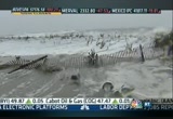
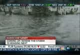
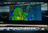
>> it is 7:00 p.m. on the east coast and hurricane sandy is hitting hard. this is a cnbc special report. the waves pounding hard-hit atlantic city, new jersey tonight. plenty of dramatic pictures. >> first we'll start with meteorologist todd gross to get the latest on the storm. >> specifically the storm is basically coming to its heights but not in terms of the water. i'll explain y.can you see some of the winds right now including right here over islip, long island. 59-mile-per-hour gust. now 78 miles per hour. and that's the strongest that we've seen so far. however, take a look at the storm surge that we're expecting just a couple of hours from now when it's high tide. you know, this is full moon coming up tonight which aggravates this a little bit, enough so that this is likely to happen. four to eight-foot storm surge around the south shore of long island, down to the east shore of new jersey. then we have the water funneling in along the long island sound, and that's going to be a big problem with a storm surge of 6
7:01 pm

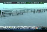
to 11 feet. what does that mean? that means that the actual water level could come up ten feet above normal to begin with, and on top of that you have additional waves. that's why that is such a serious problem. now, let's move along and talk about what's going to happen next with this storm. first of all. atlantic city was really hit very hard, and we're expecting that the worst will be right on the immediate shore line where the waves pound the coastline. i know it's hard to see, but this is actually the boardwalk in atlantic city. it has been very greatlydevasta. the economic damage to the atlantic city area is going to be a big story that we'll be covering in days to come, but the radar is showing that the rain isn't going to be an issue in the same spots that the wind is an issue. let me show you what you mean. if we draw a line to basically where the storm is moving along, moving from east to west, backwards to the north of that line, it's not raining very hard. there won't be any flooding around northern new jersey for a
7:02 pm
change, new york city up in vermont where you were hit so hard last year, and none of that, all the big rains are going to happen down in southern sections of pennsylvania through west virginia and virginia. now what's interesting about that is you also have elevation there, and there's yet another angle to this. there is, of course, snow, and the snow is in a very narrow band at the highest elevations of east and west virginia, western virginia down through tennessee. we'll be watching that as well in coming days. overall, the worst is going to happen in the next couple of hours, right on the immediate shore line with high tide which takes place at 9:00. we'll be watching. >> all right, todd. thank you. we'll be checking back with you over the next couple of hours here as well. meantime, monster storm has created a mess in new york city. powerful winds wreaking havoc, toppling a portion of this crane in midtown manhattan on west 57th street at the top of a luxury building being built right now. fire fighters have been on the scene trying to secure it and keeping it from crashing to the street below. our robert frank is there live
7:03 pm

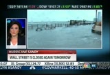
tonight and will have more on this developing story in just a few minutes, but first, cnbc's scott cohn and bob pisani are covering the impact of this storm on the financial center of the world. scott's there on the water near wall street, but first here's bob pisani reporting on wal street's rather unprecedented decision to close for a second straight day. bob? >> reporter: and here's what's important, guys. tomorrow will be another day a lot like today and what's going on here. the nyse and the nasdaq will be closed but the cboe will be closed as well, but the chicago mercantile exchange will be running futures and options includiso everything will be closed and the big push is on wednesday. wednesday is the last trading day. many traders want an opportunity to trade on the last day. in addition it's the end of the career for some funds.
7:04 pm

they, too, may want to trade. so the pressure is on to open wednesday. nyse is hoping to open the nyse floor, even if it's just a skeletal staff and even if it's only for just a few hours. of course, the other exchanges will be open as well. they are actively working on ways to get the traders in, assuming that it's safe. the one thing that could throw a monkey wrench into all of this is if the bridges and tunnels are closed, but the bet is by late tomorrow roads, bridges and tunnels are going to be open even if the subways are going to be shut. they are really determined to open this thing on wednesday. >> the last time the new york stock exchange closed more than one day for -- related to weather was 1888. >> that's right. >> that's how long it's been. >> haven't seen it in a long time. the determination now to get this thing open on wednesday because of the close of the month, a lot of these professional firms want the ability to have that final mark to show to their investors, and some people want to dump winners and losers for the end of the month. >> sure. we normally do get trading activity. >> and also the ability for financial markets to function in
7:05 pm
this country is a core value that we hold. it's one of the reasons why we have laws about how often, how many days in a row that banks can be closed, et cetera, so this is a big issue. >> yeah. nobody wants the appearance that they are in the able to actually open. the big thing is they have got to be able to convince their people that it's safe for everybody just to come in. once that happens, they are going to open immediately. >> and, of course, we can see pictures that we're looking at right now. that's the reason we won't see trading at the new york stock exchange. now correspondent scott cohn who has been watching the flooding throughout the day. scott? bill and michelle, this is what storm surge looks like. that is supposed to be the battery. it is underwater now, and they have told us that we could get another five feet of water as the tide comes in. the winds picking up here. this is not the greatest place to be. we are, of course, in the zone
7:06 pm
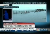
"a," the evacuation zone in new york city, and can you definitely see why that is. police have been patrolling back and forth here because there have been a lot of onlookers and they haven't been able to keep out of the park. this is getting to be a serious situation, and we will eventually be moving further and further inland. if you are watching cnbc this morning, i was reporting from around where the railing is there, and the water was ankle deep. that water has now come up, and we're well above the levels that we were during hurricane irene. that was expected as the storm surge now comes in, and as i said the wind picks up, and it's going to get worse as the -- as the evening goes on. all of the bridges now in and out of manhattan closed. the east river and the hudson river as well as the verazzano bridge that connects brooklyn and staten island. manhattan literally is now an
7:07 pm

island. there is also now the concern that conedison the local utility has raise that had they may have to do preemptive power outages, if it looks like some of the low-lying areas are going to flood to protect the underground equipment. they would do power outages, so so much for the utility of having utilities and elect call wires under a ground. that can be an issue as well when storm surges rise. we'll be back with more as our special coverage goes on. guys, back to you. >> thank you so much, scott. that's why we have so many issues with the exchange. that's the neighborhood where the new york stock exchange is. back to the dramatic picture in midtown manhattan, a construction hanging from a skyscraper. robert frank is live in new york city with more on that. robert? >> reporter: thanks, guys. well, i'm standing on 57th and 8th, just a couple of blocks from where this crane is hanging like a giant sword over midtown manhattan. here's what we know so far. at approximately 2:45 today the boom of that crane was blown over the cab, over the top and
7:08 pm

is now hanging over the building. the mayor has evacuated this entire area, all of the buildings directly surrounding 157, have been evacuated and including a hotel. the d.o.b. and the fire department has sent personnel up into that building, but as winds and rain get even worse here in midtown, it's unclear that there's any kind of temporary fix. for now, everybody is just waiting and hoping that this crane does not fall. now, this, of course, was already one of the most high-profile buildings in new york city, the tallest residential tower in manhattan, penthouses in this building selling for more than $90 million. the construction contractor who is ultimately responsible for the crane is also under scrutiny. this is the company that had to pay millions of dollars for a billing scandal. there's going to be a lot of questions in the coming days as to whether they followed procedure. they said this crane was inspected on friday afternoon, but there are going to be questions as to whether they follow the city procedure for tying that crane down.
7:09 pm
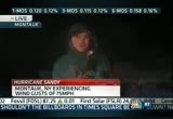
a special person for the company told us that they are, quote, praying that no one is injured from this, as are we all. back to you, guys. >> robert, dramatic video there tonight. thank you. talk to you later. long island is in an especially bad position for this storm extending out into the ocean. lots of pricey real estate. brian schactman reports to us live from montauk. what's going on down there? >> reporter: we've had a little bit more rain in the last few minutes but generally speaking it has not been a rain event. it's been a wind and a storm surge event. can i tell you in the last hour the storm surge is violent, but it hasn't gotten worse. we're about an hour away from high tide. the last dune where i stand right now has -- >> looks like we're having trouble with brian schactman's report. if you look at your map, he's at the very eastern tip in the green, the farthest point on
7:10 pm

long island. hence, one of the reasons why we're having trouble with that signal. >> even then as we test the technical limits there, he's on the south shore of long island. it's the north shore that's had the worst of it because of the swells as the water makes its way from east to west and then makes its way on over to manhattan, so long island is really taking the brunt of it tonight. >> it often does in the storms because it extends, a peninsula that extends out into the water. from long island to the jersey shore, a report now from the shore. >> reporter: we're 14 feet above sea level here and with the storm surge between 10 and 12 feet that's very important here. 10 feet is what's above the normal sea level or ocean level here, and we're seeing 30-foot waves as this post-tropical storm sandy is finally making its way inland.
7:11 pm
here in cape may severe record flooding because that have storm surge. streets are flooded. the land behind me is flooded, but this pales in comparison to what we're seeing up in atlantic city. todd gross was mention is it earlier. of course, the videos are extremely devastating when you look at type of water damage that has occurred, even before sandy has made landfall this evening. of course, impacting that even further is just about an hour envelope when this region gets high tide. that will only further the amount of water that is coming ashore. we should mention that new jersey officials were attempting to rescue roughly 500 residents of atlantic city who were stranded ahead of sandy's landfall. chris christie noting that a lot of these people are unaccounted for. may be too late to get them until morning. 250,000 people without power here so it's going to be a long night if you're on one of the barrier islands. >> just lost her shot there. >> be safe. haurricane sandy is forcing several major oil refineries to
7:12 pm
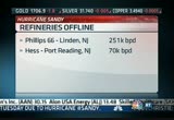
shut tight and you know what that does to gas prices. mary thompson is live from baltimore. >> reporter: hey, bill, you know, brian schactman on live and sandy is south, of course, of the storm system, the storm north, and that's where the refineries in the northeast are located. now, in the wake of today's storm, and, of course, pending what happens tomorrow, a couple of refineries and some pipelines have shut down. let's give you the rundown. the linden refinery in new jersey or the phillips 66 shutting down completely along with the hess refinery. we have three others that are running at lower run raise, basically operating at very minimal levels, but they can get up and running again once the storm has passed. there's one refinery that was recently acquired by the airs. the airlines said it was operating normally and was monitoring the storm and might change if conditions merited.
7:13 pm
today the east coast refiners are accountable for 6.6% of total gasoline production here in the u.s., but keep in mind as storms keep the people off the street, demand for gasoline goes down. lebeau and associates say demand could be down about 1.5 billion barrels, even, if the refineries get up and running or production should be down by 1.5 million barrels provided the refineries aren't damaged, and they can't get up and running. la lastly, most notably colonial is shutting down its pipeline, again, because of damage from the storm. >> we're having trouble with mary's shot as you can tell. taking a lot of hits to mary's shot. thanks so much, mary. we'll dip into our sister network, the new york affiliate for the nbc family. they are covering some of the damage that we're seeing in the new york city area. take a listen. >> a partial crane collapse to where we are now which is 14th
7:14 pm
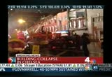
street and eighth avenue. the winds have picked up dramatically. i literally could not stand in the sidewalk. there is -- there are pieces of metal from the front of buildings flying through the street. it's actually terrifying. people have started to scream. there are a lot of people out and about. i think if it wasn't earlier, it is definitely time to head indoors. clearly dangerous out here. we are told, it's important, i should have mentioned this already. fortunately there were no injuries in this partial building collapse on eighth avenue between 14th and 15th street at this time. >> melissa, do you know if there was any construction going on at that building? >> it does not look like a construction site. it literally just looks like the front of the building blew off. >> amazing. >> like a dollhouse. >> and you can see, contessa, the fire fighters, even though they are not fighting a fire, they are wearing their bunker
7:15 pm

gear because obviously it's safer if they are out there as melissa said with stuff flying around. they are ascending and the ladder is trying to do what to figure out doing with this building. that affords them quite a bit of protection the helmets and heavy jackets. >> you think it's terrifying to see stuff, metal flying around on the street. imagine the people inside that apartment when all of a sudden the facade of your building comes down. >> yes, if they were there, my gosh, that would have been horrifying. >> chuck scar bow and contessa brewer at wnbc in new york, looking at the devastation of a partial building collapse in chelsea, just more evidence of the devastation of sandy, the havoc that it's wreaking with the heavy rain and he have winds at this hour. >> the wind, what struck me, was the reporter saying we're hearing people screaming. >> yes. >> as things start to fly through the air. the wind event is pretty tremendous. new jersey governor chris christie furious about the lack of evacuation planning in atlantic city. now he's telling people there
7:16 pm

we're not coming for you until tomorrow. that's next. plus, where the insurance industry expects the most damage, and how hurricane sandy is creating havoc for the airline industry as well. as bad as the flights can'tlations wecan' cancellations were today, tomorrow even worse.


7:19 pm
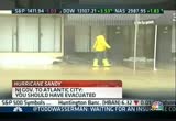
welcome back. in new jersey a storm within the storm has erupted tonight as atlantic city floods. governor chris christie engages in a fight, very public fight, with the mayor of that city. the governor says he told the people of atlantic city to evacuate, but he says the mayor there had another message. >> for those of you who are on the barrier islands who decided it was a better idea to wait this out than evacuate and those elected officials that decided to ignore my admonition this is now your responsibility. if you're still able to hear me we need you to hunker down and get to the highest point possible in the dwelling that you're in. we will not be able to come and help you until daylight tomorrow. >> and those aren't even some of
7:20 pm
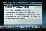
the harshest words that the governor had for the mayor of atlantic city. we have a call in to the mayor of the city for more on his side of the story. we haven't heard back yet. we know there was a longtime feud between the two gentlemen. we do have a recent newspaper report quoting the atlantic city. three feet, four feet of water in the city will disable a lot of our vehicles. we won't be able to respond even if we want to so we want the resident to take every precaution to get out of town, and if they can't or for whatever reason they won't, at least go to a shelter located in the city, and governor christie was ve critical of him saying that, that the shelters even within atlantic city aren't going to be safe. >> not a strong message in his feeling. >> exactly. >> it was not get out now while you can. >> yes. he equivocated in his view. as is sometimes the case these days, the most dramatic pictures and best video of a storm like this don't come from our photographers, they come from you. courtney reagan and her team have been combing the social media posts and tweets, and she's got a lot more on what's
7:21 pm

been going on on social media. >> it's hard to pick. social media is a hard tool for spreading communication and closures and power outages, very effectively. lots of folks spreading updates from government officials, power companies and news organizations really helping to get that word out. sandy, new jersey, fema, business, hudson river, tappan zee bridge, all of the top trending topics on twitter. instagram has seen thousands of photos taken. interestingly delaware is the state with the highest amount of buzz around the storm followed by new jersey and then connecticut, but a picture is really what's worth a thousand words, and there are thousands of them. here are just a few. the fdyn, as you with see here, putting up a picture of the waves crashing into the bridge in brooklyn and then if you look over here, we've got a picture of the white house. this is the situation room.
7:22 pm

president obama tweeting out this very powerful. moving over here, you've got sandbags in jersey city, new jersey, justin solomon out with our reporter brian schactman in montauk tweeting that picture, and that's only gotten worse since then. there's more pictures from monta montauk. nbc's ron allen in atlantic city. check out this picture of al roker from this morning imagine what this must look like now in point pleasant, new jersey. can you see here we've got the fdr in new york city. over water. i mean, these pictures just get more and more compelling as you move on. it's unbelievable. we're going to keep following this as they come in, but for now, bill, back over to you. >> a highly photographed storm, that's for sure. thanks very much. hurricane sandy could cause as much as $20 billion in economic damage and losses. how much of that impact is going to be felt by the insurance industry? don griffin is with us tonight with the property casualty and insurers association of america. don, thanks for being with us tonight.
7:23 pm
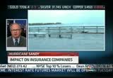
>> a pleasure to be here. >> lots of superlatifs have been heard to describe the size and magnitude of this storm. do you have any sense yet of the possible cost of this storm for the insurance industry? >> well, it's awfully early for us to tell as it's just making landfall today, but one thing i would make sure of is that seeing all the pictures that you've had on earlier and the people that, as you mentioned, were screaming, one of the things that needs to be emphasized and cannot be emphasized enough is people first and foremost need to be safe, so they need to get to safe places and stay there until they have been given the all clear. >> heed the warnings obviously. >> yes. >> often what happens with the devastation like this is people discover what is not covered in their policies and that often involves flooding, doesn't it? >> yes, sir. no coverage under a homeowners or traditional commercial building policy for flood insurance, and for flooding, and so that's a separate policy. it's purchased through the local agents, but it's backed by the
7:24 pm
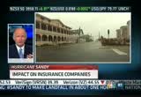
federal government through the national flood insurance program, so certainly people need to, and hopefully they have had those policies, and what we're seeing here is obviously the wind storm is very devastating, but the flooding is even more problematic as we see that due to the storm surge. >> and then the power outages and the damage from the wind because this is a heavily wooded area we're talking about in these portions of new jersey moving out into pennsylvania and down to west virginia and virginia. a lot of trees will come down. a lot of damage can be brought at that point, can't it? >> certainly looks to be a more powerful storm than irene was last year. as we recall, it was a little over $5 billion for our industry for that particular storm. certainly that was just the property and casualty side, not the flooding, so we expect that this will be at least of that magnitude, although we don't know for sure until there's been some real estimates, and it takes usually a couple of weeks for us to get any real hard
7:25 pm
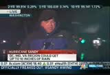
numbers that we can track. >> don griffin, thanks for your thoughts tonight, appreciate it. >> thank you. a lot of the focus today has been on new york city because it is the financial center of the country, but clearly points further south and soon to the north are in trouble as well. hampton pearson is live in washington where federal workers will get another day off tomorrow. hampton? >> reporter: hi, michelle. more about that in a moment. we did get word late this afternoon that treasury secretary the guy anyner had a meeting with the financial security oversight council about financial markets, hurricane sandy approaching and the bottom line, treasury officials are saying, all major payments, clearing and settlement from a are operating normally, even using backup contingency sites if necessary. now, to the storm itself and impacts here on d.c., right now we're in the middle of what forecasters are telling us could be up to 10 inches of rain. we've also got a lot of wind as well. gusts up to 50 miles per hour
7:26 pm

just in the last hour and a half or so. about 75,000 people are already without power. that's according to estimates of the major utilities serving the d.c. area, baltimore and northern virginia, and, of course, we know the worst of the storm is still very much ahead for this area overnight. earlier today maryland governor martin o'malley voiced really the concerns of a lot of officials in this area. when it comes to urging people to seek shelter and get off the roads. >> this is going to be a long haul. the days ahead are going to be very difficult. there will be people who die and are killed in this storm. we are ordering and urging all marylanders to stay off the roads for the next 36 hours. >> now, much -- much of the federal government, local governments, d.c. schools will, of course, be closed again tomorrow. we have no amtrak service to speak of up here. all the major airports, dulles,
7:27 pm

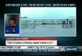
bwi, reagan national, all flights are cancelled going forward. we're also looking at some of the more compelling images around here in the nation's capital. arlington national cemetery, of course, closed, but we did get these images of the tomb of the unknowns, the soldiers walking their post always as scheduled during the day, earlier today. now out there in an enclosed shelter, as we speak. one other casualty here in the d.c. area, we've had early voting in maryland and d.c. cancelled today and again tomorrow. michelle and bill, back to you. >> all right. thank you very much, hampton. scott cohn, our correspondent in lower manhattan, has just been hit with the storm surge. this is the area around the new york stock exchange. he joins us on the phone. scott, how bad is the flooding. >> michelle, it's pretty bad in the tip of manhattan. when we spoke to you, we were in battery park. we knew we were taking a calculated risk but did not expect the water to come up as
7:28 pm
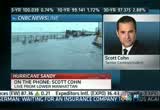
fast as it did. just about when i sent it back to you at top of the hour, i found water lapping around my feet well away from the river. that water came up very fast, and if you know manhattan at all, i can tell you the staten island ferry terminal, that's the part where the people go in, is now, if it's not flooded it's close to it. there's almost certainly water in the subways now. they had sandbagged the subway entrances down there, but we had to high tail it out of there very fast as the water was rising. i've covered quite a few hurricanes that. may be one of the most harrowing experiences i've ever been through, just trying to get out of there as that water came up fast. now, where i'm standing now is just around the corner from the new york stock exchange in the heart of the financial distribute. here it's relatively dry, and the winds are relatively calm. just a lot of police presence and not a lot of people, so as far as the financial infrastructure, it should be
7:29 pm

okay over here, but in that critical part of manhattan that has a lot to do with getting around and also the potential of water getting into the subway system, those fears of a historic storm surge in lower man heatan are being realized. >> scott cohn, if you don't know, covered katrina for us, ap he's prone to understatements, so when he says he went through one of the most harrowing experiences he's experienced. >> says a lot. >> a pretty dramatic statement. you highlight, scott, why you can have so many deaths due to flooding in situations like this, because that water moved so fast and with so much power. >> it does, and as i said, again, at the top of the hour, i said they told us there wou about five more feet of water. we expected it to be a little more gradual than it was, and when it comes up, it comes up fast. it's not a wall of water. it's just that all of a sudden you find yourself with a lot of water around you, and then you're scrambling into your vehicles, including your
7:30 pm

satellite truck, trying to get out of there with water basically coming up over the foot. i mean, it was that bad. you know, we are all fine. everybody got out of there in one piece, and we hope to be able to send you some pictures later on this evening, or at least tomorrow morning, but it was quite an experience. >> i'll bet. scott, stay safe. you and your crew there, good job, thank you. looking at live pictures now along the jersey shore. this is seaside heights. this will be the area where sandy will make landfall any time now. it could be in the next half hour to an hour, and we'll watch this area very carefully. there doesn't appear to be any flooding at this point, but there's an area that will be vulnerable certainly as sandy makes its way towards the shore. >> we've been talking about all the physical damages, also major political impact of the storm itself as it comes in the midst of a heated presidential race. >> what does it mean for the president, for governor romney? a lot. larry kudlow and john harwood weigh in on that coming up next. also coming up tonight, a
7:31 pm

storm chaser. he's run with sandy from the nation's capital all the way up to new york. we'll see what he's been up to coming up. ybe it was half an hoe showed you we thought the water will probably come on to tdd#: 1-800-345-2550 let's talk about low-cost investing.
7:32 pm

tdd#: 1-800-345-2550 at schwab, we're committed to offering you tdd#: 1-800-345-2550 low-cost investment options-- tdd#: 1-800-345-2550 like our exchange traded funds, or etfs tdd#: 1-800-345-2550 which now have the lowest tdd#: 1-800-345-2550 operating expenses tdd#: 1-800-345-2550 in their respective tdd#: 1-800-345-2550 lipper categories. tdd#: 1-800-345-2550 lower than spdr tdd#: 1-800-345-2550 tdd#: 1-800-345-2550 and even lower than vanguard.
7:33 pm

tdd#: 1-800-345-2550 tdd#: 1-800-345-2550 that means with schwab, tdd#: 1-800-345-2550 your portfolio has tdd#: 1-800-345-2550 a better chance to grow. tdd#: 1-800-345-2550 and you can trade all our etfs online, tdd#: 1-800-345-2550 commission-free, from your schwab account. tdd#: 1-800-345-2550 tdd#: 1-800-345-2550 so let's talk about saving money, tdd#: 1-800-345-2550 with schwab etfs. tdd#: 1-800-345-2550 schwab etfs now have the lowest operating expenses tdd#: 1-800-345-2550 in their respective lipper categories. tdd#: 1-800-345-2550 call 1-800-4schwab tdd#: 1-800-345-2550 or visit schwab.com tdd#: 1-800-345-2550 to open an account today. tdd#: 1-800-345-2550 funding is easy tdd#: 1-800-345-2550 with schwab mobile deposit. tdd#: 1-800-345-2550 investors should consider tdd#: 1-800-345-2550 carefully information tdd#: 1-800-345-2550 contained in the prospectus, tdd#: 1-800-345-2550 including investment objectives, tdd#: 1-800-345-2550 risks, charges, and expenses. you can obtain tdd#: 1-800-345-2550 a prospectus by visiting tdd#: 1-800-345-2550 www.schwab.com/schwabetfs. tdd#: 1-800-345-2550 please read the prospectus tdd#: 1-800-345-2550 carefully before investing. tdd#: 1-800-345-2550 a live picture of times square where the rain is pouring down. an area that usually has what, thousands and thousands of people, completely empty tonight and not a single vehicle. that is an amazing sight.
7:34 pm

>> amazing. >> the storm impacting the last week of campaigning. join you go is john harwood in washington and larry kudlow in new york. john, i'm going to start with you. both campaigns having to alter what they are doing because of hurricane sandy. >> reporter: no question. president obama came back to the white house. he ditched his events in florida today and then in wisconsin tomorrow. mitt romney's done the same thing, cancelling events tonight and tomorrow. it's a difficult situation for candidates. of course, they both rin tinsley competitive. they want to win. president obama said i'm not thinking about the election. of course, he is thinking about the election all the time, so are his people. they know that or they believe that they have an advantage in battleground states and that perhaps the freezing of attention to the campaign will benefit them with a limited time to go. on the other hand, mitt romney can point to national polls and say i've gotten the upper hand since the first debate, so we will see whether the ground games get affected by this. obama's generally considered to
7:35 pm
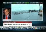
have the more extensive and effective ground game. that, of course, is going to be tested on election day, but if some of that is interrupted, he and his people could be affected, and we'll see whether the early vote in places like north carolina, for example, where it matters some and florida is shaken up by this. >> and some that have early voting has been cancelled, larry. who does this hurt more in, your view? which candidate stands to lose the most as a result of this disruption of the campaigning? >> well, it's a very tough call. look, mitt romney has tremendous momentum behind him. not just in national polls. he's got state poll momentum in iowa and wisconsin, for example. today rasmussen just gave him the nod in ohio, that's the first time, so the question you want to ask is does this slow romney's momentum or not? i don't really think it does. i think the heros of this thing is neither candidate. it's guys like chris christie and andrew cuomo and mcdonnel down in virginia. those are the guys who are getting the attention.
7:36 pm

this is primarily a state and local event. speaking of virginia, if you want to look at a place that could be affected just by the physicalness of this hurricane or super storm, northern virginia which is going to be hit hard, already been hit hard, that is an obama stronghold for early voting, number one, which is going to be taken out of play, and number two, it's possible if there's a power shortage up there that that could affect the voting, paper ballots, no w.h.o. knows. >> over on msnbc, our liberal sister network, says this storm proves how important it is to have the federal government. could that be used as a way to help the federal government? >> that's old hat liberal thinking. it just doesn't fly, and in fact one of the themes of this whole race is that the federal government no in emergencies, lord knows this is an emergency and this is a public safety issue, it's not really a political issue, but i think that too much spending associated with president obama is not a good thing for him, and romney's had a pretty solid message here, bipartisanship and
7:37 pm

economic growth, but getting away from all that, i don't think this is clear. i think the story is sandy. i don't think it's the two candidates for the next two or three days. >> certainly, john harwood, the story now is about getting people safe and saving lives and making sure everybody is out of harm's way and if devastation is enough and people are still out of power next tuesday, that could be a real problem come election day. >> absolutely it could. i've never seen an election day actually disrupted in a way that seems possible in this instance. so, you know, we'll have to wait and see how extensive and long lasting the power outages are. you know, to the extent that they are on some east coast states where, you know, president obama has had a substantial lead, you could see that it may not affect the outcome in some of those states, but, on the other hand, if you're talking about florida, talking about virginia, these are highly competitive states, and we can't predict how it's
7:38 pm
going to affect it. >> thanks, guys. talk to you later. we've been looking at that video of the capitol building. no, there is no fountain around the capitol. that was rain. >> rain. >> just incredibly visible with the lights, the volume of water that's coming down. unbelievable. >> and we go back to that video that you just saw there. that's point pleasant, new jersey, far from pleasant today. look at the flooding already at this point. this is well before landfall today. >> and well before what they expect will be the worst of the flooding. what will new york city look like tomorrow along with points north and south? more of cnbc's special coverage of hurricane sandy is straight ahead. when you take a closer l. ...at the best schools in the world... ...you see they all have something very interesting in common. they have teachers... ...with a deeper knowledge of their subjects. as a result, their students achieve at a higher level. let's develop more stars in education.
7:39 pm

let's invest in our teachers... ...so they can inspire our students. let's solve this. on gasoline. i am probably going to the gas station about once a month. last time i was at a gas station was about...i would say... two months ago. i very rarely put gas in my chevy volt. i go to the gas station such a small amount that i forget how to put gas in my car. [ male announcer ] and it's not just these owners giving the volt high praise. volt received the j.d. power and associates appeal award two years in a row. ♪ appeal award two years in a row. customer erin swenson bought so, i'm happy. today. sales go up... i'm happy. it went out today... i'm happy. what if she's not home? (together) she won't be happy. use ups! she can get a text alert, reroute... even reschedule her package. it's ups my choice. are you happy? i'm happy. i'm happy. i'm happy.

7:41 pm
take a look at your screen. this is an area called battery park in lower manhattan as earlier today water in the harbor rose over the barrier. tomorrow could be worse. the weather channel's dr. greg postell is tracking the storm. greg? >> reporter: yeah, that's right. yeah, right now we are looking at sandy which is now super storm sandy, and it has come onshore. what we're seeing now is a wind direction along long island sound that is primarily out of the east, and that's piling up water on the west side of long island sound.
7:42 pm
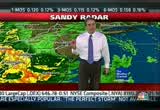
what we're watching for is as sandy continues to move inland, what's going to happen ais the winds along the south shore of long island will turn around to the south and that will start piling up water to the south of long island and bring a lot more water in very quickly in places like raritan bay and places close to new york city. can you see this on the radar right in front of you. what we've got here may not look like a lot of rain but very strong winds. winds have gusted to over 90 miles per hour in parts of long island. we have a very serious situation not only with the strong winds but primarily now it's a surge problem because south shore of long island and very close to new york city, again raritan bay, the water levels are going to rise very quickly because of the change in wind direction from the east to the south and that will happen over the course of the next several hours. back to you. >> all right, greg, thank you very much. we're going to try again to make contact with cnbc's brian schactman in the thick of the storm tonight in montauk on long island. brian, what's going on, buddy?
7:43 pm
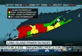
>> reporter: well, billy -- bill, sorry, it's interesting what the meteorologists just said because so far out here the storm surge on the south shore where i am in montauk has not been as impactful on the storm surge on the north shore in long island sound which has had tremendous damage which might reverse. the storm surge has been bad but hasn't gotten worse. in terms of town here in east hampton, falling trees have been a major issue here and not so much flooding from rain. i look back at irene, they had maybe half a million outages, and we're already at 600,000 plus outages on long island, and we still have a ways to go. that's the thing that people need to take away in terms of geography. we're in the eastern point of long island, and there was a fear at one point that we might get cut off, that the atlantic ocean might cut over to the sound. there's less of a fear of that that would effectively cut us off, but generally speaking the
7:44 pm
22,000 full-time residents of east hampton did not leave. they have hunkered down and we have a couple here with us, though there's more staff staying at the inn than there are people enjoying their time off in the hurricane. back to you guys. >> thanks so much, brian. stay safe out there. ahead on cnbc's special coverage of hurricane sandy, what comes after the storm? we'll be right back with all that and more next.


7:47 pm

hurricane sandy making a slow and powerful push into the northeast. scott cohn has been in battery park city all day long in the southern part of manhattan. here's what his day has been like. >> reporter: you wouldn't know to look at things now that there's a big storm coming in. things are definitely getting worse. it is high tide at the battery so that's some of what's going on here. take a look. the water is now up to my ankles. the waters are looking very angry, but we have not had a lot
7:48 pm
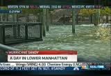
of the effects of the storm yet because it's still a couple -- a good couple hundred miles further down the east coast. the tide has gone down somewhat, so i'm somewhat high and dry. at the moment it's just sort of a miserable, cloudy, cold, rainy day. it is getting progressively worse. the wind is kicking up here. this happens in fits and starts as sandy gets closer. the waters behind me, new york harbor is getting angrier and angrier. probably will be the last report that we do from this location here because as you may be able to see the waters in new york harbor are now starting to lap up on to this esplanade here at the battery at the tip of lower manhattan. >> that is scott cohn covering the storm from lower manhattan and joins us once again. scott, when we talked to you 20 minutes ago you had to evacuate because of the storm surge. what's the latest on the stage of flooding down there? >> reporter: well, we're still trying to figure out what exactly happened with subways and the staten island ferry
7:49 pm

because we had to get out of there very quickly. i don't have anything authoritative to tell you right now. i've come quite a bit inland. we're now at the lower tip of broadway. if you're familiar with the ticker tape parades that they have in the canyon of heros in manhattan, that's where we are now, somewhaticslated from the wind and certainly insulated from the water. what they tell you about storm surge, and, you know, we've been through a few of these, that it comes up pretty fast, and it does. after we spoke to you at 7:00 eastern time, we told you that the water was about a nine-foot storm surge. as we got off the air i could see that the water was coming up around my feet, and within a very short time after that we had to get out of there with all deliberate speed and barely did get out as the water was overtaking our vehicles. so that's just a sense of the surge, and let's hope that now as -- as now tropical storm sandy comes inland and at least the hurricane forces diminish,
7:50 pm
we deal with all the rest of it, it will make its way out of here fairly quickly. this being the financial center here, it is high and dry. it was always going to be high and dry, but issue now is getting people in to work, and that's why you've seen the closures with all the financial exchanges and why they are going to take some time to get through all of that, and -- and we will try and get through figuring out exactly what flooded and what didn't, but the concern was the subways would flood. i can tell you it's fairly likely that some water did get in there. >> very quickly, scott, as you mentioned, quite a portfolio of other storms that you've made it through on our behalf. how do you compare this one with those others? >> well, you know, i've covered storms in the gulf coast a number of times. this is the first time i've done one in new york city, and it's in a lot of ways a different animal. you learn how fragile a big city can be, a big strong city like this. it's just different, and that surge, as i said, was really
7:51 pm

something to behold. >> yeah. >> scott cohn, thank you very much. see you later. coming up next, hurricane sandy hitting long island's massapequa hard tonight turning streets into rivers. more on how the storm is ravaging the northeast and how refineries are being affected as well. we'll be back in two minutes.


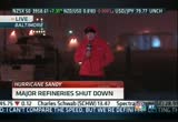
7:54 pm

welcome back. sandy has closed several of the region's major refineries. here's a look at the process to reopen these fuel centers. cnbc's sharon epperson has more. >> reporter: getting a refinery back online after a full shutdown due to a hurricane or major storm can be a lengthy multi-phase operation. the first step, returning evacuated personnel to the refinery, could take a few days depending on conditions and surrounding areas. once on location, the crew evaluates the storm damage, like flooding or downed power lines. if the power is out, the refinery has to wait for local utilities to restore it. once power is back, the team will restart the refining units. this is done in the sequence of the actual refining process. at a large facility there could be dozens of machines in the lineup, and each individual machine might require a day or
7:55 pm

two days to start up. but nord for the refinery to get back to business it needs crude oil to process. however, storm damage could be trapping the oil tankers and, therefore, supply could be stuck offshore. all told, it can sometimes take up to two weeks to get a refinery up and running again. even a small facility could require as long as seven ten days. >> you're looking at the bottom of the screen there, one of the major bridges into new york city, the rfk triborough has been closed due to 100-mile-per-hour winds. pretty dramatic. triple digits. >> unbelievable. the weather channel's paul walsh is here. those are the numbers you get up in a high rise in the middle of the city. >> extremely strong winds for the northeast. this low pressure system is now the lowest on record. >> and that's significant why? low pressure is what's -- >> that's what is giving us the strong winds, really strong gradeients. even though the storm has been
7:56 pm
classified as a non-tropical event, not downgraded, no longer tropical. what we're calling at the weather channel a superstorm. >> that's out in queens area there, sort of behind where the storm is at this point, northeast of the storm. >> right. >> is that typical of what you get in the north side of a storm is where you're going to get most of the wind anyway is. >> and the right quadrant so that basically is this area. it's just now moving through, so we're getting into the strongest part of the winds which is why we're seeing, of course, with the high tide also the flooding that we're seeing now with, you know, the folks up in that area. >> we're talking wind here, but brought you up to talk about the business impact of this storm. >> right. >> and, of course, retail will be hard hit in a very critical area and a very critical time of the year. >> absolutely. >> ironically, october will probably benefit from the storm because of the timing over the weekend that fit into the october fiscal. november is going to take a haircut obviously because we're going to lose really the first
7:57 pm

fiscal week of the retail calendar for a large portion of the country about, 25% of the population will be impacted by the storm because of what's happening now. the next two days we'll lose traffic, and we'll also likely lose power for the balance of the week, so that will have a negative impact on retail. citigroup put out a report saying they thought it would be a 2% to 3% negative impact on retail. >> more from you coming up in a little bit. thanks, paul. all right. coming up next hour of the cnbc special report on hurricane sandy, how a professional storm chaser is viewing this hurricane. >> and we'll get larry kudlow's take on how the storm could impact gdp, the strength of the nation's economy. we'll be right back. < [ male announcer ] at scottrade,

7:59 pm

we believe the more you know, the better you trade. so we have ongoing webinars and interactive learning,
445 Views
IN COLLECTIONS
CNBC Television Archive
  Television Archive News Search Service
Uploaded by TV Archive on
